In the 2020 KISS workshop, when Dr. Vincent Humphrey first presented his result to correlate GPS signals to canopy water content, I was fascinated by the findings. We are using GPS all the time, whether recognizing it or not. One thing clear is that when we are directly exposed to the sky, we have good GPS signals; and when we are sheltered by anything, we get weak signals. So, can we make use of the signals to estimate the things surrounding us, like trees? The short answer is YES!
When installing one GPS receiver at the top of the canopy and one at the bottom, the signal difference is then fully attributed to the canopy (and canopy airspace) in between. Should any change in the differential signal, it is due to the canopy (and canopy airspace). With this technique, we should be expecting to see the diurnal and seasonal changes in the differential signals, which reflect the changes in the canopy.
The microwave signal used by GPS satellites can well penetrate through the atmosphere but still gets absorbed by molecules like water. Therefore, any change in canopy water content would lead to changes in the differential GPS signal. However, as the differential signals are also impacted by the atmosphere (like weather) and satellites (raw signal and satellite position), they are transformed to a unitless vegetation optical depth (VOD) to describe the canopy. In this case, when the canopy water content is high, VOD is high (equivalent to a thicker canopy).
Many factors could impact the VOD retrieved from global navigation satellite system (GNSS), including but not limited to
- Leaf/Stem area index,
- Leaf/Stem water content,
- Leaf/Stem biomass, and
- Canopy structure.
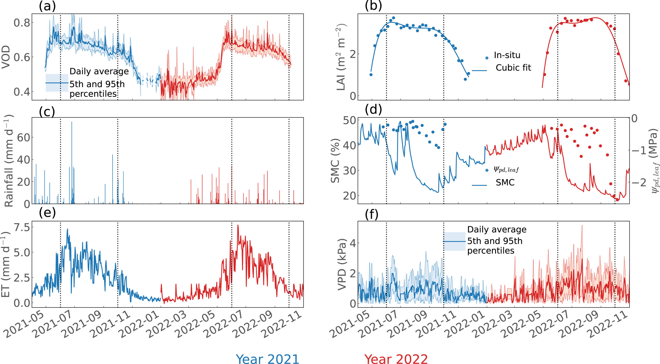
For example, higher leaf area index and water content lead to higher VOD, and higher biomass leads to higher VOD. As leaf and stem biomass are not supposed to change dramatically in a day (unless due to leaf shedding), we can utilize the GNSS VOD to estimate the canopy water content dynamics. Season-wise, the GNSS VOD can be used to decode leaf area index dynamics as stem biomass is not changing substantially. Further, as the canopy is not fully closed as if it is a cloud of leaves, we should be expecting to see signal variation at different satellite viewing angles.
In the most recent paper by Yitong Yao (Yao et al., 2024; Geophysical Research Letters), we used the pair of GNSS receivers deployed at the Ozark flux tower site to see how the GNSS VOD data can be utilized to maximally exploit its potential. We did find that the VOD changed in a diurnal cycle, in a seasonal cycle, and with satellite position, showing great potential in estimating canopy water content and biomass. Surprisingly and also as expected as well, the VOD noise was related to precipitation, which is equivalent to increasing leaf water content, meaning it can also be used to “see” the weather!

The GNSS VOD not only can be used to invert not canopy water content, its time series can also be used to to estimate transpiration rate (site-level calibration required). When coupled to sap flux measurements, the results would be useful to quantify the exact amount of water in the canopy. For more details, please check out the paper and Yitong’s blog.
I can see the great potential of the technique being more sophisticated and being used at more places across the globe, say at each flux tower site, and on the campus. Imagine that one day, we can install two cell phones or watches to log the GNSS signals. But better to use the waterproofed ones.